
The Ausangate Circuit has to be one of the most insanely spectacular least-known treks in the world. It's one of the highest in Peru -- never dropping below 14,000 feet -- including 4 mountain passes, continuous glacial views, multiple high-altitude lakes, and thousands of alpacas.
 |
| Ausangate from the way up to Arapa Pass |
Chris and I had been referring to Salkantay, the first trek of our 12-day Peru trip, as our warm-up trek, but Ausangate was the main event and primary motivation for going to Central Peru. Though rarely featured on top-whatever listicles, Besthike (a rather insider source) ranks it as the fourth best in the world. Let me tell you guys, I think that might be right. There wasn't a moment that wasn't spectacular, and I don't use that word lightly. The trek traverses the Cordillera Vilcanota, circumnavigating Apu Ausangate, the fourth highest mountain in Peru at 20,945 feet, and offers insane views all the way.
 |
| Laguna Uchuy Pucacocha (I think) |
Our advance planning for this trek, however, was (typically) minimal. We thought that the Rainbow Mountain (Vinecunca) was part of the Circuit, but turns out it's not! Luckily we popped into a travel company on our one day in Cuzco between treks and met the most helpful man who enabled us to do ALL THE THINGS.
 |
| Chris taking pictures on the way to Campo Pass |
Just in case you want to recreate, here's the short version of our itinerary:
Day 1
- Get picked up at 3am, drive to the start of Vinecunca/Rainbow Mountain hike, hiking by 7am.
- Hike up to Rainbow Mountain and back [~5-6 hours]
- Drive to Lower Upis and meet up with horseman [~3 hours]
- Hike to Upper Upis [~2 hours]
Day 2
- Hike starting at Upper Upis >>> Arapa Pass (4757m/15,600ft) >>> along Laguna Uchuy Pucacocha and Laguna Jatan Pucacocha (lakes) >>> Apacheta Pass (4850m/15,908ft) >>> Laguna Ausangatecocha [~6-8 hours]
Day 3
- Laguna Ausangatecocha >>> Palomani Pass (5165m/16,941ft) >>> Pampacancha (village) >>> Campo/Jhampa/Jampa/Q'ampa Pass (4850m/15,908ft) >>> Jhampa Campsite [~10 hours]
Day 4
- Jhampa Campsite >>> Laguna Q'omercocha (lake) >>> Pachanta (town) >>> Tinki (town) [~5 hours]
- From Tinki you can take a taxi or local bus (10 soles) back to Cuzco. [~4 hours]
 |
| Ausangate + alpacas |
We started our first morning at long-before-morning o'clock (i.e. 3 am) to drive to the Rainbow Mountain (Vinecunca). This is a simple but challenging out-and-back hike (no guide necessary) that starts at 4326m/14,189ft and climbs to 5,020m/16,466ft in just 2-3 hours. But if you're feeling lazy or sick (don't be lazy or sick!) you can hire one of the many local Quechua to lead you on the back of a horse the last section up. We, of course, were on a tight time table, so we did it quick-quick, but spent a while at the top taking pictures because duh. I was SO into this you guys. I'd been seeing pictures of this for weeks, but in person it was just...wow. So much wow.
It's impossible to get the full sense from pictures, but this ridge is quite high, with glaciers behind and miles upon miles of colorful red ridges contrast with clear blue sky ahead. If you look behind my head in the picture you can see (very tiny) the saddle, where there's a little rock structure at the immediate base of the rainbow part and many people stop. But you must walk up the mountain to the opposite to get the full view. Again, wow.
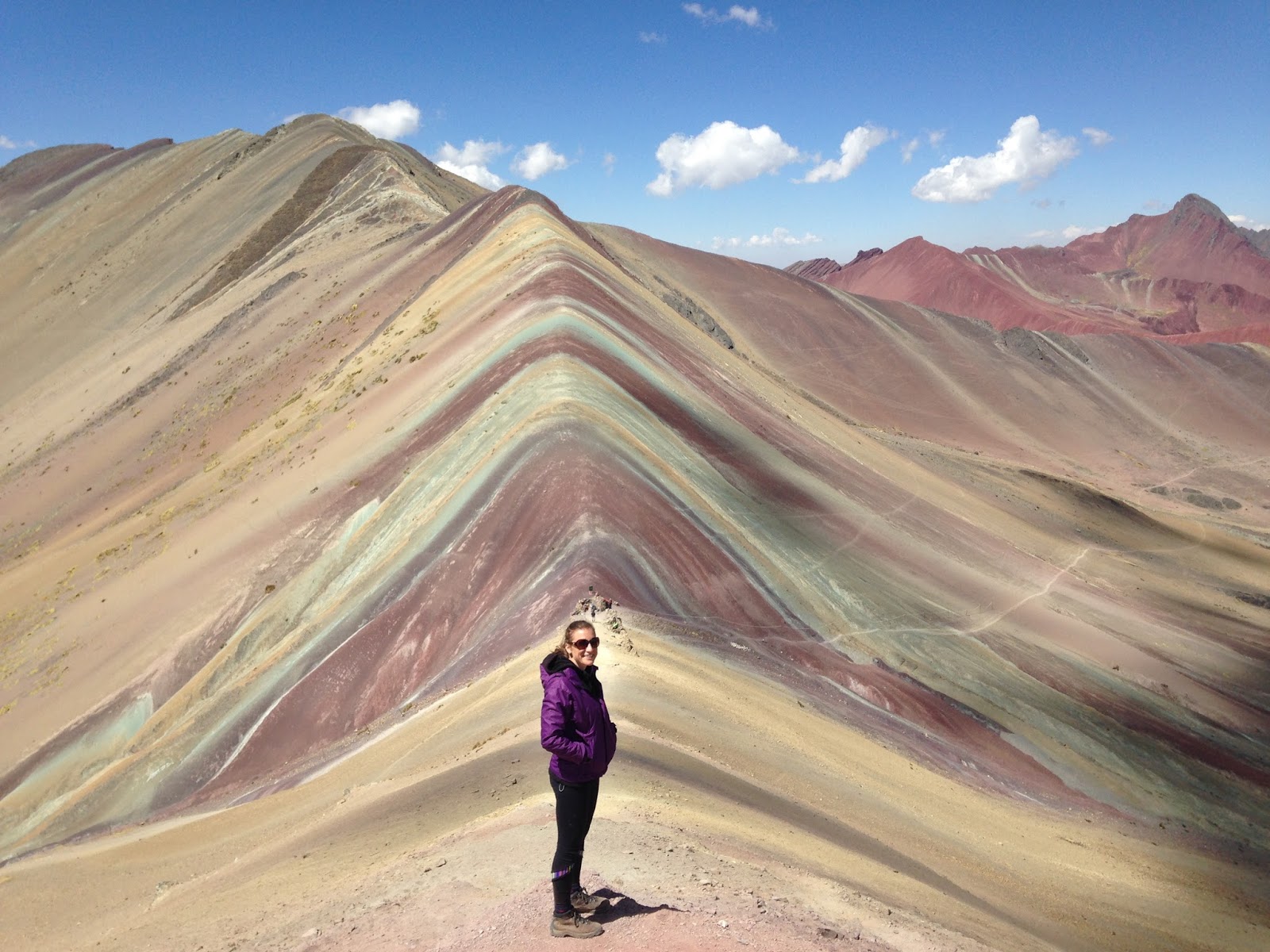 |
| Rainbow Mountain/Vinecunca |
We learned later that the Rainbow Mountain was covered under a permanent blanket of glacial snow until a couple of years ago, so being able to see it today is a disconcerting mix of sad from a global warming perspective but amazing from a things-I-get-to-see-in-my-life perspective. Sigh. At least they're limiting where you can walk now (stay on the trail!) to try to preserve its awesomeness.

A 3-hour car ride later, our true trek started in Upper Upis (aka Upis Alto) at a breathtaking (literally) 14,035 feet.
Because of our Rainbow Mountain morning, we didn't meet up with Pablo Santiago (our hired horseman/guide/cook) and his trusty steed (henceforth known as "Caballo") until 4:30 pm. Pablo loaded Caballo with a stove and fuel, food, and our tents, while our backs carried the rest of it all.
We trekked for a solid two hours through alpaca farms and fields, coming closer and closer to a cloud-enshrouded mountain in the distance. That night we spent in a "home stay" -- basically someone's shed turned into a bunkhouse -- since it was super windy, completely dark, and kinda raining when we finally finished walking.
Upon arrival, our first of many communication woes with Pablo ensued. Conclusion: he wasn't down to cook us dinner (unclear why...to our detriment we speak very little Spanish and 100% zero Quechua, the local language). So after a solid 7-hours of extremely high altitude up-and-down hiking we inhaled some bread and salami and cheese and lay down to sleep, tightly sealed into our sleeping bags against the uncomfortably large spiders that infested the house. (Ok fine fine they were totally normal-sized, but I still didn't want them snuggling with me.)
Day 2
The next morning we awoke long before dawn cracked to the sounds of Pablo cooking. Oatmeal with raisins and sugar?! we thought hopefully, as we had purchased 5 days worth of delicious hiking food for the three of us and were really hoping to actually eat some of it. It was not to be. He presented us with heaping plates of a boiled rice and fried pasta mixed together, with a few tomato slices and salt on top. Weird. Unexpected. Ok.
Our first full Ausangate day (technically day 2) was quite a day. It started with the climb to Arapa Pass (4757m/15,600ft). We acquired a joyous perro (= dog) along the way who had absolutely no problem running ahead of course. We learned later that he belonged to an alpaca herder who is friends with Pablo, but enjoys joining trekkers for long sections of their hike.
Arapa Pass was shortly followed by a gentle down then a very steep up to our first lakes of the trek. [Pro-tip: fill your water bottles where the trail crosses the stream at the mouth of the first lake, as there is literally no water for hours after that point. We learned this lesson the very hard and veerrryyy thirsty way.]
 |
| Arapa Pass + Perro |
The first is Laguna Vinecocha, then you skirt upwards to its south side and pass by Laguna Uchuy Pucacocha and Laguna Jatan Pucacocha with rocky redish steeps to your right, views of Ausangate across the lakes to your left, and alpaca and sheep farms right in front of you. I think Chris probably averaged one picture for every five minutes of trekking -- totally reasonable considering the prevalence of Proper Pointy Peaks (PPPs). We'd seen a group of French people first thing in the morning, but other than that just one American couple the whole day. But the area certainly wasn't deserted -- local Quechua, tending their flocks (?) of alpaca, walk up and down these passes constantly, the women dressed in colorful skirts and sanq'apa (traditional hats elaborately decorated with sequins, flowers, rick-rack, and beads) and the men sporting cowboy hats on top of colorful chullo (Andean ear flap llama or alpaca wool hats).
 |
| Laguna Jatan Pucacocha + alpacas |
The next pass of the day (we were in a haze of dehydration at this point) was the Apacheta at 4850m/15,908ft. Since we were already so high at the lakes it didn't feel like much of a climb, but the subsequent steep down down down afterwards belied its pass-worthy-ness. Our day's trek concluded around 1:30 pm at Laguna Ausangatecocha where you pay 10 soles per person to a Quechua lady to camp. The lake sits in between a high glacier and an alpaca-studded valley with red and brown hills in the distance. Pretty freaking cool.
 |
| Laguna Ausangatecocha |
Upon arrival, Pablo, realizing our super thirsty state, made us a whole pot of tea and commanded us to "augumenter" (which turns out is not a word in Spanish...what was even happening?) our cups again and again until we finished it all. We hoped for something delicious and satisfying for dinner (as apparently Pablo doesn't believe in stopping for lunch), only to be unpleasantly surprised by the exact same rice-pasta-tomato situation we'd had for breakfast. We groaned, morosely shoveled it in, laid down for a long night in the tent, comforting ourselves in the knowledge that we'd just completed an 8-hour trek in 6 and our campsite was SUPER amazing -- yet another one for the REI catalog collection.
 |
| Laguna Ausangatecocha Campsite |
 |
| Same campsite, different angle. |
The next morning started with exceptionally early tea in our tent, followed by a confusing but thank-God-it's-not-rice/pasta/
 |
| On the way up to Palomani Pass looking back at our campsite |
 |
| Chris on top of Palomani Pass |
The trail down led along a long dusty mountainside to the valley and village of Pampacancha below, with mountain views and alpacas all the way (of course). We walked along Rio Chilcamaya past the village then skirted around some boggy flats (Pampa Jatunpata) before starting northwest up along the Rio Jampamayo. This view distracted me from my very tired feet.
 |
| Pablo + Caballo I think this is Senal Nevado Pico Tres, but I'm not 100% sure. |
Chris and I were under the impression that we'd be done by 1:30 (Pablo had said something around 10:30 about us finishing in 4 hours) and were looking forward to it. Going over high mountain passes is tiring work! But as we passed by the village of Jampa and continued to carry on we started to get a little bit concerned and a little bit upset.
When we finally caught up to Pablo (he tended to take the horse waaaay far ahead of us and then sit on a rock chewing coca leaves until hola amigos! we arrived and then he was off again), we asked him how much further and he responded with a shrug, tres horas mas o menos. TRES HORAS?!? What. No. How. I was none too pleased about this scenario but resigned myself to plod along as long at it took. (We realized later that when we'd thought he said 4 more hours what he really said was we'd be finished at 4pm. Very different for tired trekkers.) I gave Caballo my sleeping bag to carry, because really I have nothing to prove here.
The ensuing hike up the valley, however, was absolutely stunning as we walked directly at a range of unknown peaks (later identified as Senal Nevado Pico Tres and Nevado Puca Punta).
 |
| On the way to Campo Pass. |
We were shocked and confused to go over what appeared to be a very significant but completely unrecorded pass late in the day -- beautiful and cairn-covered as it was -- and assumed it was oddly missing from our map. The sign at the top said Jampa Pass, which was not listed in our Lonely Planet Trekking in the Central Andes (blog research recommend this book for its descriptions of the trek, even though it's been out of print since 2002).
So what happened?? At a long airport layover on the way home, intently consulting the internet and our guidebook, we realized that Jampa is the same as Q'ampa is the same as Campa is the same as Campo pass (which was in our book). So it turns out that Pablo, our tricky tricky horseman, led us over THE TWO HIGHEST PASSES on day three. No wonder I was tired beyond tired. But also, look!
 |
| Campo/Jampa/Jhampa/Q'ampa Pass |
Did Pablo drag us over an additional peak because he was so impressed with our fitness and had overwhelming faith in our astounding pass-hiking abilities? Or was it a more selfish motivation, knowing that the sooner we finished the sooner he could go home and pocket the extra day's pay? Or -- and after much debate we think this is the most likely answer -- our guidebook map, which we used to point out the location we wanted to camp, has the town of Jampa labeled (which is before the pass) but as of 2013 a bunch of new campsites have been built and Jampa is the name of a campsite on the other side of the pass. So Pablo probably did what we asked (camping at Jampa), it just wasn't what we thought we were asking for.
Conclusion: learn Quecheua. Or Spanish. Or just suck it up and keep waking and enjoy the hot soup and yet another stunning campsite at the end.
 |
| Jampa Campsite, view of Apu Ausangate |
After one final freezing night (temperatures during the day were in the 60s and 70s, but at night dropped to the high teens), we awoke looking straight up at the pointiest view of Apu Ausangate yet. Ok ok Ausangate, you win. Though breakfast was again rice/pasta/tomato/salt...so there's that.
[Day 4 pictures to be added in the next couple days (my camera died) -- check back they're good! For now here's a picture of an alpaca.]

What a trip.
